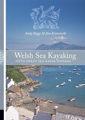
Along with the previous two titles already mentioned, Pesda Press sent me ‘Welsh Sea Kayaking: Fifty Great Sea Kayak Voyages’ by Jim Krawiecki and Andy Biggs to read and review as well. I must confess to being slightly apprehensive about reviewing this one as I have never kayaked in Wales and probably am unlikely to with regards to touring – being an angler I’m more inclined to paddle out to a mark, fish it, and come back in again so am perhaps not best placed to give an opinion. However, on reading it I was soon aware that it didn’t really matter that much. As a guide to the coastline and fifty selected voyages it’s again not a read-once-and-be-done-with-it kind of book. Instead it whets the appetite for expeditions and gives advice on each of these. I must confess to not having read it cover to cover; rather I have dipped in and out here and there at places throughout the book as I would were I planning to do some selected trips on a holiday, say, in Wales. It is NOT a book designed with the purpose of reading from front to back although it is certainly possible, and someone familiar with the area will find it interesting and inspiring to do so. I did, however, read a fair amount of the book (probably two-thirds) and feel able to give my review. Here are the details and the publisher’s synopsis:

Welsh Sea Kayaking: Fifty Great Sea Kayak Voyages. Jim Krawiecki and Andy Biggs.
Paperback: 272 pages
Publisher: Pesda Press (14 Sep 2006)
Language English
ISBN-10: 0954706188
ISBN-13: 978-0954706180
Product Dimensions: 23.8 x 16.8 x 2.2 cm
Synopsis
From the Dee Estuary to the Bristol Channel, the Welsh coastline in all its varied guises provides a fantastic playground for the sea kayaker. The fifty journeys selected cover all of the interesting parts of the coast and provide easy sheltered paddles, testing offshore trips for the adventurous and everything in between. Illustrated with superb colour photographs and useful maps throughout, this book is a practical guide to help you select and plan trips. It will provide inspiration for future voyages and a souvenir of journeys undertaken. As well as providing essential information on where to start and finish, distances, times and tidal information, the book does much to stimulate and inform our interest in the environment we are passing through. It is full of facts and anecdotes about local history, geology, scenery, seabirds and sea mammals. It is a fascinating read and an inspirational book.
I’d go along with that.
Physically, the book consists of thin card covers printed in full colour. The front and rear carry photographs and the inner covers carry a basic map of Wales with numbers purporting to each trip at the front and an advertisement for Surf-Lines in the rear. Further relevant adverts are also printed in the rear. Once again, in common with the previous Pesda Press offerings I’ve read, the book is printed on thick, high-quality matte paper and is full-colour throughout – it’s another quality production and this does justify the price.
The layout of the book is very clear. A sharp, clear font with easy-to-read line-spacing and a large amount of clear, sharp, well-exposed and colourful photographs (on almost every page) give a feeling of brightness throughout. The graphics (maps and basic charts) are simple and clear to read. Images are clearly captioned so you know what and where you are looking at. The text is easily-digestible being written in a style that flows without waffling or becoming too dry – the authors giving plenty of detail broken down into relevant sub-headings. Additionally, the front features a full contents page and the back a detailed index. Overall, it’s a very nice-looking book that looks and feels like a quality product. It would be a fine addition to any travelling kayaker’s shelf.
Now for the content, the important part:
The book begins with a note on coastal access in Wales along with paragraphs regarding the environment, respect and camping as well as a reminder about the dangers of sea kayaking.
Following this is a section informing the reader of how to use the guide. It explains the layout of the sections, how trip classifications translate and map symbols used along with an example.
The next section is a page regarding the authors and their experience; both are experienced sea kayakers and this reinforces the background to the information contained inside.
There follows an introduction to the North Coast of Wales and an overview of tides and weather along with suggested further reading. Three trips in this area are give. Next comes the Anglesey / Ynys Môn region and a further 12 trips. The Lleyn Peninsula has another 7, Cardigan Bay 5, Pembrokeshire 16 and the Gower and Bristol Channel 7 more. Plenty to chose from from all around the country. So, what does a trip guide consist of?
Picking one truly at random (indicative of them all) I chose Porth Dinllaen to Porth Oer, the top 1/3 of the page taken up with a suitably inspiring photograph. This is voyage No. 17, it is classified Grade B ( mid-range voyage in terms of distance and difficulty), is 19km long and can be found on Ordnance Survey sheet 123. The nearest tidal port is Liverpool.
That’s the general info listed at the top. Next comes start and finish locations (with grid references), high water and low water time differences for the ‘local’ tidal port, tidal stream times, tidal rates (max spring rate) and the coastguard information of telephone number and VHF weather report channel.
These put the paddler in the know of the basic details necessary for the voyage. Next comes the main text:
The introduction mentions historical and geographical information along with some pointers of how best to enjoy the route.
The description follows, giving basic travel directions to the start point (including parking tips). It then mentions ebbs and overfalls (and how to avoid them) and proceeds to describe the journey in more detail including things you might see en-route, along with some possible exits to campsite, pub and post office and an alternative finishing point. It ends with notes on landings at the end.
Tide and Weather comes next, this gives details on wind directions and their effects along with advice on when during the tide it is best to depart in order to take advantage of the ebbing tidal stream. It also mentions the forming of overfalls at certain times and the effects of wind over tide conditions.
Additional Information in this instance mentions a grocers shop, other shops and a petrol station. Campsites (and phone numbers) are also listed.
Variations is the last section – those listed here are reversing the route and alternate start and finish points.
This particular voyage is accompanied by two photographs, an ‘interest’ insert regarding Porth Dinllaen Harbour and another about ‘The Wreck of the Stuart’. Finally, half a page is given to a clear map indicating local roads and towns/villages along with suggested route, and details marked on such as high/low water times and tidal rates and the location of
possible rough water.
That’s certainly a pretty detailed guide to that trip! The rest are more or less covering the same formula although not all have ‘interest’ inserts.
The book finishes with the Appendices. First up is Coastguard and Emergency Services including a map of who covers where, their telephone numbers and the times of weather announcements on VHF Channel 16.
Appendix B is weather information. Local and national radio weather forecast times are given as is the met office website address. A note on VHF radio follows with regards to weather and navigation and details of obtaining forecast by telephone are also given.
Appendix C lists Pilot books for the area.
Appendix D lists mean tidal ranges.
Appendix E is a glossary of Welsh language place names.
Appendix F gives recommended reading.
Appendix G is a guide to the use of the Trip Planning Route Card which follows and ends the book.
So, having had a tour and description of the book it is time to provide a personal opinion. First off, it is not a book I would have gone and bought on myself simply because I would be unlikely to make use of it as a kayak angler who is unlikely to make these voyages. That said, were I situated in Wales rather than directly opposite in Suffolk then it would be a book I would make space for as it has plenty of useful information that I would appreciate having at my fingertips as well as being a prompt to try other locations and the odd bit of touring. It’s a well written book; it is descriptive and does precisely what it is intended to do. It is inspiring and readable and if you use it properly you are assured of a voyage in which you are well briefed and prepared for. It’s not an ideal literary companion inasmuch as providing a book to read in the general manner but is rather useful at the bedside – I went to sleep with it two nights in a row! I must add that this was not because it was boring but rather because it was a pleasant way to end the day; half a dozen voyages at sea to go to sleep with in your mind. A word of warning though, if just straight ‘reading’ it does sometimes feel like you are being bombarded with detail. If reading to plan a trip though it is spot on and as its set out to allow parts to be glossed over this is fine.
So, is it a worthwhile purchase?
If you just want to read about kayaking then no. Other titles will provide more entertainment value. If you are intending to take a trip to Wales for kayaking, or live in the area though then I would deem it to be very worthwhile. It’s certainly worth the price in this respect as it is a large book of good quality production with extensively-researched and exhaustive coverage of its content. So yes, although not one for me generally it’s a thumbs up again and I’ll keep it just in case I head west…
Oh yeah, and page 182 has the best kayaking photograph I have seen. Absolutely first-rate.
Mark Crame
March 2008
This book is available direct from Pesda Press by clicking here.
Click here to check out the latest price on Amazon.co.uk


